

Marseille
• Bouches-du-Rhône (13000) • Population: 800,550 • Altitude: 12 m

Gallery of 21 photos for Marseille

Spelling. Marseille in French, Marseilles in English, but no change in the pronunciation (mar-say').
Marseilles is a Provencal city with vitality, centered around 26-century-old port, with a dynamic downtown, big parks, a medieval-village-style neighborhood, downtown shopping and wonderful seafood. If you have an "image" of Marseilles that isn't good, a visit here will be a wonderful surprise. The photo is of the L'Escolo de la Mar; this Marseillais folk-dance group was founded in 1854 by Frédéric Mistral and his friends, making it the oldest in France.
• Market day Daily.
Marseille | Old Port | Fish Market | Panier | Longchamp | Shopping | Museums | History | Tours | Transportation |
Marseilles is, first of all, ancient. Started by the Phoenician around 600-BC (ignoring of course the Ligurians who already lived here), taken over by the Greeks in 540 BC, and conquered by the Romans two thousand years ago, it is full of sites and artifacts of Antiquity. Marseilles is the second-largest city in France, with its metro and its Parisian-style division into "arrondissements".
The flavor of Marseilles is antiquity, seaport, seafood, museums, history and travel. On the darker side, the reputation of Marseilles included gangsters and plague, with the gangster reputation from the "old days" accented by many French films and the American film "The French Connection". The plague gained its entry into Provence in 1720 from a ship of silk and cotton unloaded at Marseilles.
Marseille Maps
![[villphotos]marseille075b400.jpg](../picsvill2/marseille-townmap001b400.jpg)
Marseille Area Map
shows the area where Marseille is located.
Marseille Town Map
shows the location of some sites in the town.
Marseille Marignane Airport Area Map shows the area of Marseille and the Marignane airport.
Old Port (Vieux Port)
![[villphotos]marseille075b400.jpg](../picsvill2/marseille075b400.jpg)
The Old Port (Vieux Port) is the hub of Marseilles, lined by its quais, filled with fishing boats and yachts, and surrounded by small streets teeming with seafood restaurants and shops. The wide quais are popular places for leisurely strolling, and the many terrace cafés opposite provide handy "rest stops" for when you're tired of walking. You can even make a "loop" of the Old Port, walking around three sides and taking the little ferryboat across from one side to the other.
Old Port Fish Market
![[villphotos]marseille-fish003b400.jpg](../picsvill2/marseille-fish003b400.jpg)
The Quai des Belges, at the end of the port, hosts a fish market, every morning of the week, that has a life of its own. You can watch the small fishing boats arrive at the pier, set up their stands with the catch of the day, and see individuals and restaurant chefs selecting and buying the seafood.
Panier
![[villphotos]marseille0457b400.jpg](../picsvill2/marseille0457b400.jpg)
The Panier district is like the medieval villages of Beyond. From the Old Port, Le Panier is visible as a hill of tightly-packed old houses behind the north side of the Quai du Port, behind the Hotel de Ville. Just a few minutes walk takes you up step-streets of brick and stone, to the Place de Moulins at the top.
This is a "quartier" with both character and pride, with many open squares, good terrace restaurants, and the amazing Marseille Panier Street Art.
Longchamp
![[villphotos]marseille-longchamp0006b400.jpg](../picsvill2/marseille-longchamp0006b400.jpg)
The Longchamp area, centered around the Palais Longchamp, is about 2 km northwest of the Old Port. From the Square de Stalingrad at the top of La Canebière, Bvd Longchamp runs through an area of business and residential apartment buildings (not very interesting) to the Palais Longchamp.
Canebière

The 17th-century Canebière avenue runs from the end of the old port through the center of the city to the Square de Stalingrad (where it continues on as Bvd de la Liberation). La Canebiére was grand during the Second Empire (the time of Napoleon III's rule from 1852-1870, when the fine old buildings lining the avenue were built. Today, most of the lustre is gone, although the bustle and activity at the bottom part is reminiscent of the older Canebiére that symbolized Marseilles and helped make it famous.
The name Canebière came from the Provençal word canèbe (hemp), for the rope factory that was once here. During the Middle Ages, hemp fields (chènevières) in the drained marshes at the end of the Old Port produced the hemp. The local factory wove the hemp into rope for rigging the sailing ships using the port.
The many streets running off from La Canebière are the best shopping areas, like Rue St. Férréol and Rue de Rome. The Cantini Museum is at the bottom this area, of to the right about six blocks. About half way up La Canebière, on the right, is the Place du Marché des Capucins, with a daily produce market.
Place Général-de-Gaulle, at the end near the old port and opposite the Borse, is a popular meeting place for the locals. The ground floor of the stock exchange building houses the Chamber of Commerce and the Marseilles Maritime and Commercial Museum.
La Major Cathedral - Cathédrale de la Major

Old La Major Cathedral - Ancienne Cathédrale de la Major
The large Romano-Byzantine style cathedral, with its spectacular domes, was built in 1852-93. The smaller Romanesque-style "Old Major" cathedral, huddled down at the side, was built in the middle of the 11th century. Part of earliest building was chopped off during the 19th century to make room for the new cathedral.
Pharo Park - Parc du Pharo
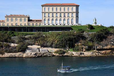
This is a large, grassy park on a low hill at the far end of the old port, on the south side. The park has a fine old château, lovely gardens and a great view back towards the old port. The "château" is the Pharo Palace, one the residence of Empress Eugénie, the wife of Napoleon III. The name 'pharo' comes from lighthouse, but there's none here now.
The park is relaxing, with lawns and some wide walkways, and not much activity. There is a small playground in one corner, with a few slides and merry-go-round for small children. In the wooded area near the entrance to the park, a large number of cats lounge about on the park benches and the grass, perhaps in character for this city of seafood.
It's about a 20-minute walk from the old port end, along the Quai de Rive Neuve and Bvd C. Livon.
South of the Port
![[villphotos]marseille0328b400.jpg](../picsvill2/marseille0328b400.jpg)
The area immediately south of the Old Port was built during the reign of Louis XIV, who had started the expansion of Marseilles in 1660. The docks, that had been here since 1488, were walled and enlarged in 1666, with accommodation for 20,000 people, mainly seamen and galley slaves. The old dockyards were pulled down in 1780, and the area completely rebuilt into its current form of large rectangular buildings.
Notre-Dame-de-la-Garde

The spectacular Notre-Dame de la Garde Basilica (Basilique de N-D-de-la-Garde) is visible from just about everywhere, including from the autoroute if you drive down from Aix. It sits on top of the Garde Hill with a fantastic view of Marseilles, the ports, the islands, and the hills to the north and east. It's a few blocks south of the port, with a serious up-hill climb, so car or bus cold be considered.
The 19th-century Romano-Byzantine style basilica is located on a hilltop with a fantastic view -- where the town's lookout post once stood. A chapel was built on the hilltop in the 13th century, and became a priory for the monks of St Victor. In the 16th century, the church was fortified, to defend against a threatened invasion by Charles V of Spain. In 1853, work started on the basilica, that was completed in 1899. The basilica is topped by a huge gilded statue of the Virgin, who is standing on top of basilica's 60-m high belfry.
It's about an hour's walk from the Old Port or the Pharo Park, and all up-hill. You can take the number 60 bus from the Cours Ballard, at the corner of the Quai des Belges of the Old Port, or there are parking lots at the top if you want to drive up. For walking, going directly from the Old Part is probably the easiest, arriving by the Montée; de l'Oratoire. If you arrive from the east side, however, you go up the Montée Valentin; we counted 251 steps, but frequent stops give you a great view out towards the sea.
St Victor's Basilica - Basilique St Victor
The Basilique St Victor stands near the southwest corner of the Old Port, by the Fort St-Nicolas. It's a reasonable walk from the old port, and not far from the Pharo Park.
The original site was a quarry, dug down into the stone, that became a necropolis in the 3rd century. A monastery was founded here by Saint John Cassian in the 5th century, housed in a fortified Abbey known as the "key to Marseilles harbour". The abbey was destroyed by barbarian invasions in the 7th and 8th centuries. The abbey became one of the most famous religious centers in Gaul. It passed to the Benedictines in the 10th century, and was rebuilt and fortified in 1040. It was renovated in the 13th and 14th centuries, and the monastery was destroyed during the Revolution.
Saint-Victor and his compagnions were martyred in Marseille in the year 304. Prior to that eventful date, he owned the land of the village of La Celle, near Brignole.
Although about half the abbey is gone, the remaining church, walls and Tour d'Isarn are pretty impressive. Some of the many items inside reveal the presence of a Greek quarry, and a Hellenistic necropole from the 2nd-c-BC. In the crypt are several exceptional sarcophagi, dating from the 3rd century on. The February 2nd Candlemas procession begins at St Victor's.
St-Charles District

This is the area around the main railway station, northwest of the Old Port. It's easy to get to, just a few minutes walk from the Old Port and La Canebère. It's not a great tourist area, but train stations are always interesting: it's wonderful to walk inside a building and see TGVs parked there. There's also a nice view from the top of the station steps over the city of Marseilles.
The area around the station is mostly apartments, schools, universities and other large buildings. Two blocks in front of the station, at the Place Guesde, is the Arc de Triomphe.
Arc de Triomphe or Porte d'Aix
This triumphal arch was built in 1833 to commemorate the Revolution and the First Empire wars. It's located at the Place Jules Guesde (Porte d'Aix), where the autoroute A7 arrives in the city. The arch can be seen from along the main avenue (with many names) including the Rue de Rome.
Accoules Bell Tower - Clocher des Accoules
This 12th-century bell tower, behind the "Maison Diamantée, is all that's left of one of the oldest churches in Marseilles.
Borély Park - Parc Borély

The Parc Borély is a big, lovely park, like a cross between Paris' Parc de Vincennes and New York's Central Park. Borély has winding waterways with ducks, swans and rowboats. The many pathways have, on a typical sunny weekend, strolling pedestrians and a variety of rental pedal things, like land pedalos, from six-passenger adult models to little pink pigs. Borély Park is about 4 km south of the Old Port, accessible by car or by the number 83 bus. Botanical Gardens are located at the east end of the park.
There are large expanses of lawn, some filled with the relaxing Marsaillaise families, and wide walkways sometimes teaming with strollers. There are also quiet little corners where narrow paths meander through trees and foliage. On the south side of the park, at the "back" entrance, is Chateau Borély, an imposing mansion built around 1770. The gravel area near the chateau is used as the petanque courts.
You can drive out to the park from the city center, or take the number 83 bus from the Cours Ballard, at the corner of the Quai des Belges of the Old Port. The bus follows the "Corniche John F. Kennedy" coast road, with a good view of the islands. If you drive on a sunny weekend, even in winter, the main entrance is mobbed, and parking is difficult. Drive around to the other side, or park by the Ballet School at the northen corner of Borély, and walk in through the Parc Henri Fabre and across the river into Borély.
Botanical Gardens.
Lovely gardens, with a large variety of flora, including a section of aeromatic plants and orchids.
Located at the east end of the Parc Borély, below the English garden.
Garden of Ruins - Jardin des Vestiges

This pretty archaeological park in the very center of the city (overlooked by the huge "Centre Bourse") has the ruins of the 1st-century docks and the 4th-century entrance to the fortified Greek town. Other remains include drainage pipes used to drain the swamp here at that time, an underground aqueduct, and various walls and towers. The stone used here 2000 years ago was the same "Couronne" pink limestone used for the Vieille Charité in the 17th-18th centuries.
Loubière Caves - Grottes Loubière
The Grottes Loubière contain beautiful five galleries, extending about 1500 m, with translucent draperies, columns stalactites and stalagmites.
- Location: 13 km northeast of the center; 2 km northwest of the Chàteau-Gombert.
- The caves are apparently closed to the public, and have been for several years, according to one of our readers (Sept 2004).
The Marseillaise
The National hymn of France was born in Strasbourg and raised in Marseilles. In 1792, during the Revolution, Rouget de Lisle, a young officer from the Army Engineers, composed the war-song of the Army of the Rhine (Chant de guerre de l'Armée du Rhin).
In Marseilles, during a banquet to honour 500 volunteers being sent to Paris, someone sang the song, which had been published, and everyone joined in. Copies of the song were given to all of the volunteers, who sang it at every stop on their way to Paris, rousing support as they went. When they marched through the streets of Paris singing the song, 500-strong and now very good, with their Provençal accents, the crowds loved it. It became instantly popular, and was named La Marseillaise.
Gastronomy
Marseilles must be the seafood capital of Provence, at least. The most famous seafood dish of Marseilles is bouillabaisse, world renowned and worth the reputation. The two main varieties offered in local restaurants are Bouillabaisse du Ravi and Bouillabaisse du Pêcheur. "Ravi", the most complete and including six different types of fish, is definitely a full meal. Bouillabaisse du Pêcher is smaller and lighter, with three types of fish. This is the recommended one for lunch, and even so, you'll need a good appetite to have something else with it.
Several seafood restaurants surround the Old Port, and there's a collection of them in the small walking streets beside the Quai de Rive Neuve.
The "Moules Marinière" (mussels) made here have a distinctive local flavour. They are made with a lot of onion and "herbes de Provence".
The "navette", a small Marseilles pastry baked in the shape of the boat (navette), commemorates the arrival of the Marys and Lazarus in Saintes-Maries-de-la-Mer about the year 40. The Four des Navettes, beside the Abbaye de Saint-Victor, has been baking the navette continuously since 1781. The peak of consumption occurs on the 2nd of February for the Fête de la Chandeleur (Candlemas procession).
The "Cassis" white wine is excellent with the seafood, and the Cassis blanc-de-blanc is the best. This well-known and well-respected wine is local, from the Cassis region just a few km to the east.
History of Marseille
Marseille History is shown on a separate page.
Dates
Market day: Daily.
Brocante-Antiques; Cours Julien: 2nd Sun
Brocante, Ave Cap-Pinède: Every Sat
Brocante, Ave Cap-Pinède: Every Sun
Brocante, old books; Cours Julien: 2nd Sat
Feb (2nd) - Fête de la Chandeleur, procession begins at St Victor's Basilica, and the navettes> are bought to commemorate the >Saintes Maries
Aug (15th) - pilgrimage to Notre Dame de la Garde
Oct - Fiesta des Suds - music, dances, concerts, bodegas on the docks
Nov-Dec - Foire aux Santons de Marseille - Annual Santon Fair
Hiking
• GPS: 43.297612, 5.381042
Maps
IGN (1/25,000) #3145 ET "Marseille, Les Calanques"
The Calanques. (Calanques are the steep, narrow inlets where creeks join the sea.) The GR 98 (Grande Randonnée) runs from La Madrague, on the peninsula 8 km south of the city center. Two loop-hikes circle the rocky Massif de Marseilleveyre on the peninsula. From the eastern end, the GR 98 follows the rocky coastline past the deep calanques to Cassis (about 25 km by trail from La Madrague). The GR 98 continues northeast to the Ste Baume.
Etoile. From the Château-Gombert on the north edge of the city (metro-1), there is a loop-hike onto the Chaine de l'Etoile hills. From this trail, other trails continue on and branch out through the hills to the northeast of the city.
Notre Dame Nature Hike (City). There is a 1118-m circuit around the top of the Garde Hill, marked with nature information and, of course, a great view. It's called the "Sentier de découverte botanique de la Colline de Notre Dame de la Garde".
City Walks. The Office de Tourisme has a set of 31 circuits to see different historical or artistic parts of the city. Some of the circuits are by bus, but most are for walking, and are about two hours each.
Tours Marseille
Marseille Tours are listed on a separate page.